
Siguniang Mountain Four Sisters
The taxi dropped me at the entrance to Changping Valley, and I remember the air had that particular bite to it, the kind you only get at altitude when the sun i.
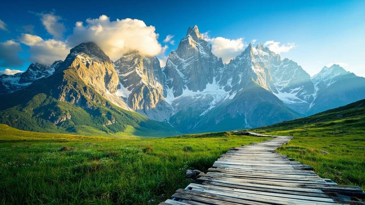
The taxi dropped me at the entrance to Changping Valley, and I remember the air had that particular bite to it, the kind you only get at altitude when the sun is out but the wind hasn’t warmed up yet. I’d been living in Beijing for years by then, but I still wasn’t prepared for the sight of those four peaks lined up like a family portrait against a sky so blue it almost hurt. The locals call them “Four Sisters” because the four snowy summits resemble four sisters standing shoulder to shoulder, and the tallest one, Yaomei Feng, is the “eldest” at 6,250 meters. I’d read about the place dozens of times, but nothing prepares you for the scale of it, the way the valley floor sits at just over 3,000 meters while those granite walls rise another three vertical kilometers above you.
Siguniang Mountain National Park, in western Sichuan’s Aba Prefecture, is one of the most accessible high-altitude mountain areas in China. It’s not like Everest Base Camp, where you need permits and a sherpa. Here, you can walk out of a tourist town, buy a bottle of water, and be on a trailhead within twenty minutes. The park is actually three separate valleys, each with its own character, plus a scenic road that runs along the base. It’s the kind of place that makes you understand why the Chinese call it “Eastern Alps” and why it’s been a UNESCO World Heritage site since 2006. This guide covers the three main valleys, the best viewpoints, and the practical stuff that nobody tells you about altitude, weather, and getting there.
Quick answer
Siguniang Mountain (Four Sisters Mountain) is a high-altitude national park in western Sichuan, China, best visited between May and October. The park has three main valleys, Changping, Haizi, and Shuangqiao, with entry fees ranging from free (parts of Changping) to about $12 USD (¥80) for Shuangqiao Valley. Most international visitors combine it with a trip to Chengdu, which is a 4-hour drive or 1-hour flight away. The 240-hour visa-free transit policy applies if you’re transiting through Chengdu, and you’ll need Alipay or WeChat Pay set up before you go because the park ticket office takes mobile payments almost exclusively.
The Short Version
If you only have one day, do Shuangqiao Valley. It’s the easiest, has a shuttle bus, and gives you the postcard views without the altitude slog. If you have two days, add Changping Valley and walk as far as your lungs allow. Skip Haizi Valley unless you’re a serious hiker or it’s October for the autumn colors. Don’t skip the altitude. Acclimatize in Chengdu for a night, then sleep in Rilong Town at 3,200 meters before attempting anything strenuous. And for the love of everything, bring cash as backup because the ATM in Rilong runs out of money on weekends.
How I Picked These
I’ve been to Siguniang four times over the past six years, twice in summer and twice in autumn. I’ve walked the full length of Changping Valley, taken the shuttle through Shuangqiang more times than I can count, and spent a miserable, wonderful night in a tent at the Haizi Valley base camp. I’ve talked to the local Jiaju Tibetan families who run the guesthouses, the horse handlers who wait at the trailheads, and the park rangers who’d rather be climbing than checking tickets. I’ve also made every mistake a tourist can make here, from underestimating the altitude to showing up in April when half the trails are still snowed under. This list reflects what I’d tell a friend, not what the brochures say.
Comparison Table
| Rank | Place | Best For | Approx Cost (USD) | Time Needed | When to Go |
|---|---|---|---|---|---|
| 1 | Shuangqiao Valley | First-timers, families, easy views | $12 (¥80) + $7 (¥50) shuttle | Half day | May–Oct |
| 2 | Changping Valley | Hikers, walkers, solitude | $12 (¥80) | Full day | Jun–Oct |
| 3 | Haizi Valley | Serious hikers, autumn colors | $12 (¥80) | 1–2 days | Oct |
| 4 | Rilong Town | Base camp, food, culture | Free | 1 night | Year-round |
| 5 | Cat’s Nose Ridge | Sunset views, photographers | Free | 2 hours | May–Oct |
| 6 | The Viewpoint at Guozhuangping | Classic postcard shot | Free | 30 min | Jun–Oct |
| 7 | Changping Horse Trail | Horseback through the valley | $15–30 (¥100–200) | 3–5 hours | Jun–Oct |
| 8 | Bipenggou Valley | Autumn leaf-peeping | $20 (¥140) | Full day | Oct–Nov |
| 9 | Jiaju Tibetan Village | Culture, architecture | $10 (¥70) | Half day | Year-round |
| 10 | Balangshan Pass | High-altitude views, panda habitat | Free | 1 hour | Jun–Sep |
Shuangqiao Valley — The Easy One That Everyone Should Do
The shuttle bus pulled away and I was suddenly alone on a boardwalk with the entire valley stretching out in front of me. Snowmelt streamed past my feet, and the sound was so loud I couldn’t hear my own thoughts. That’s Shuangqiao. It’s the most developed valley, and I usually hate that word, but here it means you can see the best of Siguniang without being an athlete.
The valley runs roughly north-south, with the shuttle dropping you at the far end, then you walk back down on a series of boardwalks and paved paths. The views change every hundred meters, from the sheer face of Yaomei Feng to the oddly shaped “Buffalo” rock formation to the wide alpine meadows where yaks graze without a care. It’s not wilderness, but it’s not a theme park either. The shuttle stops at five or six points, and you can hop on and off as you please.
The best strategy is to ride to the last stop, walk back for an hour or two, then catch the shuttle when your legs give out. The entire loop takes about four hours if you’re dawdling. The altitude here ranges from 3,200 to 3,800 meters, so take it slow. I saw a German tourist nearly pass out because he jogged the first stretch. Don’t be that guy.
📍 Location: Siguniang Mountain Scenic Area, Rilong Town, Xiaojin County, Aba Prefecture 🎫 Entry fee: $12 (¥80) + $7 (¥50) for the shuttle bus 🕒 Opening hours: 8:00–17:00 (shuttle stops running at 16:00) 🚌 Getting there: From Rilong Town, it’s a 10-minute walk to the visitor center. The shuttle departs every 15–20 minutes 📅 When to visit: May–October, weekday mornings before 10:00 to avoid tour groups 💡 Insider tips: The last shuttle from the far end leaves at 16:30, don’t miss it. Bring your own snacks because the food stalls at the stops are overpriced and mediocre. The boardwalk can be slippery after rain, wear proper shoes. If you’re short on time, do the first two stops and skip the rest, the views are similar. The ticket office accepts Alipay and WeChat Pay, but the shuttle ticket must be bought at the same counter.
I met a retired couple from Chongqing on the shuttle who’d been coming here every autumn for a decade. They told me the secret was to come on a weekday, because the weekend crowds from Chengdu turn the boardwalk into a conga line.
Changping Valley — Where You Earn Your Views
I walked for three hours up Changping Valley before I saw another human being. He was a horse handler leading a string of ponies, and he waved at me like we were old friends. That’s the thing about Changping. It’s the wildest of the three valleys, the one that requires actual effort, and the one that rewards you with silence.
The trail follows a river through dense forest, then opens up into wide meadows where the four peaks of Siguniang loom directly overhead. You can walk as far as you want, from a quick 30-minute stroll to the full 12-kilometer trek to the Muluozi base camp at 3,900 meters. Most people do the first 3–4 kilometers, which takes about two hours each way. The trail is well-marked and mostly flat, but the altitude makes every step feel heavier than it should.
You can also take a horse for part of the way. The local handlers charge around $15–30 (¥100–200) depending on the distance, and it’s worth it if you’re struggling with the altitude or just want the full experience. The horses are sturdy mountain ponies, not the prancing show horses you see in tourist photos. They know the trail better than you do.
📍 Location: Changping Valley entrance, 2 km west of Rilong Town 🎫 Entry fee: $12 (¥80), no shuttle needed 🕒 Opening hours: 8:00–17:30 🚌 Getting there: Walk from Rilong Town or take a local minibus (¥5) from the main square 📅 When to visit: June–October, early morning for the clearest views 💡 Insider tips: The trail gets muddy after rain, wear waterproof boots. The horse handlers will try to sell you a round trip, but you only need one way if you’re fit enough to walk back. Bring more water than you think you need, there’s nowhere to buy it once you’re past the entrance. The last 2 kilometers to Muluozi are steep, budget extra time. If you see yaks on the trail, give them space, they’re not aggressive but they’re not pets either.
I made the mistake of wearing sneakers instead of boots and spent the entire walk back squelching through mud. The horse handler laughed at me, then offered me a ride back for free. I took it.
Haizi Valley — The One for Serious Hikers
Haizi Valley is where I learned that the Chinese phrase “别急” (don’t rush) is a survival strategy, not just a cultural quirk. The valley is the least developed of the three, with no shuttle, no boardwalk, and no food stalls. It’s just you, the trail, and 12 kilometers of climbing to the Haizi Lake at 4,300 meters.
The trail starts at the same entrance as Changping but branches off after a kilometer. It’s steeper, rockier, and much less traveled. The reward is a series of alpine lakes, called “haizi” in Chinese, that sit in glacial basins below the peaks. On a clear day, the reflections are so perfect you can’t tell where the mountain ends and the water begins.
This is not a day hike for casual visitors. Most people camp overnight at the base camp near the lake, which requires a permit from the park office. The altitude at the lake is serious, and I’ve seen fit, young travelers turn green from altitude sickness. The best time is October, when the larch trees turn gold and the lakes are still ice-free.
📍 Location: Haizi Valley entrance, 3 km west of Rilong Town 🎫 Entry fee: $12 (¥80), camping permit $7 (¥50) 🕒 Opening hours: 8:00–17:00 (camping requires registration) 🚌 Getting there: Walk or take a local minibus from Rilong Town 📅 When to visit: October for autumn colors, July–August for wildflowers 💡 Insider tips: Acclimatize in Rilong for at least one night before attempting this. Bring a proper sleeping bag rated for below freezing, even in summer. The park rangers will check your permit and gear, don’t try to sneak past them. Hire a local guide for the first time, they know the weather patterns and can tell you when to turn back. Diamox (acetazolamide) for altitude sickness is available at pharmacies in Chengdu, buy it before you go.
I spent a night at the base camp and woke up to frost on the inside of my tent. The sunrise over the peaks was worth every shivering minute.
Rilong Town — The Base Camp You’ll Actually Sleep In
Rilong is not a beautiful town. It’s a functional, slightly scruffy settlement that exists to serve the mountain. But it’s where you’ll sleep, eat, and buy your supplies, so it deserves a spot on this list. The town sits at 3,200 meters, which means you’ll feel the altitude the moment you step off the bus.
The main street is lined with guesthouses, restaurants, and gear shops. The food is a mix of Sichuan and Tibetan, with hotpot, yak meat, and butter tea featuring heavily. There’s a small supermarket that stocks everything from instant noodles to trekking poles, and a pharmacy that sells oxygen canisters for about $3 (¥20).
The town comes alive in the evening when the tour buses leave and the hikers gather in the restaurants to swap stories. The guesthouses range from basic dorm beds at $10 (¥70) a night to comfortable rooms with heating at $40 (¥280). Book ahead in October, when the autumn colors bring in the crowds.
📍 Location: Rilong Town, Xiaojin County, Aba Prefecture 🎫 Entry fee: Free 🕒 Opening hours: 24/7, but most shops close by 21:00 🚌 Getting there: Buses from Chengdu arrive at the main square, most guesthouses are within walking distance 📅 When to visit: Year-round, but May–October is the busiest 💡 Insider tips: The ATM at the Bank of China runs out of cash on weekends, bring enough to cover your stay. The hot water in guesthouses can be unreliable, ask to see the room before you pay. The restaurants on the side streets are cheaper and better than the ones on the main road. If you need a guide for the valleys, ask at your guesthouse, the good ones are recommended by word of mouth. The oxygen canisters from the pharmacy actually work, I’ve used them.
I ate yak hotpot at a tiny restaurant on a side street and the owner, a Tibetan woman named Dolma, insisted I try her homemade barley wine. It was strong, sweet, and I had to be helped back to my guesthouse.
Cat’s Nose Ridge — The Sunset Spot Locals Don’t Tell You About
I found this spot by accident. I was walking east out of Rilong, trying to escape the noise of the construction sites, when I noticed a trail heading up a ridge. Twenty minutes later, I was looking at the entire town below me, with the four peaks of Siguniang glowing pink in the sunset light.
The locals call it “Cat’s Nose Ridge” because of a rock formation that looks like a cat’s face. The trail is not marked, but it’s easy to find, just head east from the town square and follow the dirt road that climbs the hill. It’s a steady 30-minute walk, gaining about 200 meters in altitude. The view from the top is worth every step.
This is the best place in the area for sunset photography. The light hits the peaks from the west, turning them from white to gold to pink as the sun drops. The town below twinkles into life, and the whole scene feels impossibly cinematic.
📍 Location: East of Rilong Town, follow the dirt road past the construction site 🎫 Entry fee: Free 🕒 Opening hours: 24/7 🚌 Getting there: Walk from Rilong Town, 30 minutes each way 📅 When to visit: May–October, arrive 45 minutes before sunset 💡 Insider tips: Bring a headlamp for the walk back down, it gets dark fast in the mountains. The wind at the top is brutal, bring a windbreaker. The construction site near the trailhead is active during the day, but the workers don’t mind hikers passing through. If you’re a photographer, this is the spot for the classic “peaks at sunset” shot.
I sat on the ridge with a Korean photographer who’d been coming here for five years. He told me he’d never once had a bad sunset, which I found hard to believe until I saw it myself.
The Viewpoint at Guozhuangping — The Postcard Shot
Every tourist photo of Siguniang Mountain with the four peaks in a perfect row is taken from this spot. It’s a small platform on the road between Rilong and the Shuangqiao Valley entrance, and it’s where the tour buses stop for the obligatory group photo.
I normally avoid these spots, but I’ll make an exception here because the view genuinely is that good. The four peaks of Siguniang rise directly across the valley, and on a clear day you can see every detail of the rock faces, the glaciers, and the snowfields. It’s the kind of view that makes you understand why people climb mountains.
The platform is small, maybe enough for 30 people, and it gets crowded when the tour buses arrive. Go early in the morning or late in the afternoon to have it to yourself. The light is better then anyway.
📍 Location: On the road between Rilong Town and Shuangqiao Valley, 5 minutes by car 🎫 Entry fee: Free 🕒 Opening hours: 24/7 🚌 Getting there: Walk from Rilong Town (30 minutes) or take a local minibus 📅 When to visit: Early morning or late afternoon for the best light 💡 Insider tips: The platform faces west, so the peaks are backlit in the afternoon. Morning is better for clear views. There’s a small parking area nearby where local vendors sell snacks and water. If you’re driving, there’s a pull-off on the road just past the platform that gives you a slightly different angle.
I watched a Chinese tour group take a synchronized jumping photo here, all 40 of them leaping at once. The tour guide counted down in Mandarin, and they all landed in a heap of laughter.
The Changping Horse Trail — Ride Like a Local
The horse trail in Changping Valley is not a tourist gimmick, it’s how the local Jiaju Tibetan families have moved through these mountains for generations. The horses are small, sturdy, and sure-footed, and they’ll carry you up the valley while you sit back and take in the views.
The trail follows the same route as the walking path but goes higher in places, giving you a different perspective on the peaks. The handlers will take you as far as the Muluozi base camp, about 12 kilometers from the entrance, and the ride takes about 3–4 hours each way.
The cost depends on the distance and your negotiating skills. The official price is around $30 (¥200) for a round trip to the base camp, but you can often get a better deal if you’re traveling in a group or off-season. The handlers speak limited English, but the horses understand the commands better than you will.
📍 Location: Changping Valley entrance, 2 km west of Rilong Town 🎫 Entry fee: $15–30 (¥100–200) per horse, depending on distance 🕒 Opening hours: 8:00–17:00 🚌 Getting there: Walk to the Changping Valley entrance and look for the horse handlers near the ticket gate 📅 When to visit: June–October, mornings are best 💡 Insider tips: Wear long pants, the stirrups can rub your legs raw. The handlers will try to sell you a round trip, but you can walk back if you’re fit. The horses stop for a rest at the halfway point, use the time to take photos. If you’re nervous about riding, ask for a calmer horse, they know which ones are gentler. Tip the handler ¥20–50 if you’re happy with the ride.
My horse was named “Little Black” and he had a habit of stopping to eat grass every hundred meters. The handler apologized and said Little Black was “lazy but honest.”
Bipenggou Valley — The Autumn Colors You Didn’t Know About
Bipenggou is not part of Siguniang Mountain proper, but it’s close enough that you’d be foolish not to combine them. The valley is about 60 kilometers from Rilong, and it’s famous for its autumn colors, which rival anything you’ll see in Japan or New England.
The valley runs for 30 kilometers, with a shuttle bus taking you to the far end and a series of walking trails leading back. The colors peak in mid-to-late October, when the maple and larch trees turn every shade of red, orange, and gold. The contrast with the snow-capped peaks is almost unreal.
The shuttle bus costs $20 (¥140) including the entry fee, and it’s worth every yuan. The valley is less crowded than Siguniang, even in peak season, because it’s less well-known internationally. The locals from Chengdu know about it, though, so expect crowds on weekends.
📍 Location: Bipenggou Valley, Li County, Aba Prefecture, 60 km from Rilong 🎫 Entry fee: $20 (¥140) including shuttle 🕒 Opening hours: 8:00–17:00 🚌 Getting there: Take a bus from Rilong to Li County, then transfer to a local bus or taxi. Or hire a driver for the day, about $50 (¥350) 📅 When to visit: October 15–November 5 for peak colors 💡 Insider tips: The shuttle bus stops at three points, ride to the last one and walk back. The colors are best in the morning when the sun hits the valley floor. Bring warm clothes, it can be near freezing even in October. The food at the entrance is basic but filling, try the yak meat skewers. If you’re driving, the road is good but winding, take your time.
I met a group of photographers from Guangzhou who’d been coming here every October for a decade. They told me the secret was to wait for the clouds to clear, which they did, right on cue.
Jiaju Tibetan Village — A Step Back in Time
The Jiaju Tibetan Village is a 30-minute drive from Rilong, and it feels like stepping into a different century. The village is a maze of white-walled, flat-roofed houses built into the hillside, with watchtowers rising above the trees. The Jiaju people have lived here for centuries, and they’ve preserved their language, customs, and architecture.
The village is best known for its “hundreds of watchtowers,” stone structures that were once used for defense and communication. Today, they’re a UNESCO World Heritage site, and they make for incredible photos, especially in the late afternoon light.
You can walk through the village freely, and the locals are friendly and used to visitors. There are a few guesthouses if you want to stay overnight, and the home-cooked meals are some of the best I’ve had in Sichuan. The village is also a great place to buy handicrafts, including the intricate embroidery the Jiaju women are famous for.
📍 Location: Jiaju Tibetan Village, Danba County, Aba Prefecture, 30 km from Rilong 🎫 Entry fee: $10 (¥70) 🕒 Opening hours: 8:00–18:00 🚌 Getting there: Hire a driver from Rilong for the day, about $50 (¥350), or take a local bus to Danba and transfer 📅 When to visit: Year-round, but spring and autumn are best 💡 Insider tips: The village is a maze, get lost on purpose. The watchtowers are best photographed from the road below the village. The locals sell apples and walnuts in autumn, buy some, they’re incredible. If you stay overnight, ask for a room with a view of the watchtowers. The embroidery is expensive but worth it, it takes months to make.
I had lunch at a family guesthouse where the grandmother insisted I try her pickled vegetables. She was 80 years old and had been making them for 60 years. They were the best I’ve ever had.
Balangshan Pass — The Roof of the World
Balangshan Pass sits at 4,500 meters, which makes it one of the highest road passes in China. It’s on the road between Rilong and Wolong, and it’s worth the drive just for the view from the top. On a clear day, you can see the entire Siguniang range spread out below you, with the peaks looking like islands in a sea of clouds.
The pass is also home to a population of wild giant pandas. The Wolong Panda Reserve is just down the road, and the bamboo forests around the pass are prime panda habitat. You’re unlikely to see one, they’re shy and rare, but just knowing they’re out there adds to the magic.
The road over the pass is well-maintained but winding, and it’s closed in winter due to snow. The best time to visit is June–September, when the wildflowers are in bloom and the weather is stable.
📍 Location: Balangshan Pass, on the road between Rilong and Wolong 🎫 Entry fee: Free 🕒 Opening hours: 24/7, but the road is closed in winter 🚌 Getting there: Hire a driver from Rilong for the day, about $60 (¥420), or take a bus to Wolong and transfer 📅 When to visit: June–September 💡 Insider tips: The altitude at the pass is serious, take it slow. There’s a small parking area at the top with a viewpoint and a toilet. The road down to Wolong has several hairpin turns, sit in the front seat if you get car sick. If you’re lucky, you might see wild pandas on the slopes below the pass. Bring binoculars if you have them.
I stood at the pass and watched a cloud bank roll over the peaks below me. A Chinese tourist next to me said, “This is what heaven looks like,” and I didn’t disagree.
FAQ summary
Siguniang Mountain is best visited between May and October, with Shuangqiao Valley being the easiest and most accessible option for first-timers. The park is reachable from Chengdu by a 4-hour drive or a combination of bus and local transport, and the 240-hour visa-free transit policy applies for international visitors transiting through Chengdu. Entry fees range from free to $20 (¥140) depending on the valley, and mobile payment apps like Alipay and WeChat Pay are essential because the ticket offices and most local businesses don’t accept international credit cards. Altitude sickness is a real concern, with Rilong Town at 3,200 meters and the highest trails reaching 4,500 meters, so acclimatization and proper preparation are critical.
FAQ
Q: Do I need a visa to visit Siguniang Mountain? A: If you’re transiting through Chengdu and qualify for the 240-hour visa-free transit policy, you can enter China without a visa for up to 10 days. This covers most international visitors flying through Chengdu Shuangliu or Tianfu airports. Otherwise, you’ll need a standard L tourist visa, which you can get from your nearest Chinese embassy or consulate.
Q: How do I get from Chengdu to Siguniang Mountain? A: The most common option is a direct bus from Chengdu’s Chadianzi Bus Station to Rilong Town, which takes about 4 hours and costs around $15 (¥100). There’s also a new expressway that cuts the drive time down to 3.5 hours if you hire a private car, which costs about $80 (¥560). The nearest airport is in Chengdu, and from there you’ll need to take ground transport.
Q: What’s the best time of year to visit Siguniang Mountain? A: May through October is the best window, with June and October being the peak months. June has the clearest views and the most stable weather, while October brings the autumn colors in Bipenggou Valley and the surrounding forests. Winter (November–March) is cold and snowy, with many trails closed and the road over Balangshan Pass shut.
Q: How much does a trip to Siguniang Mountain cost? A: Budget around $50–80 (¥350–560) per day for a comfortable trip, including accommodation, food, and entry fees. A basic guesthouse room costs $10–20 (¥70–140) per night, meals are $5–10 (¥35–70), and the valley entry fees are $12 (¥80) each. Hiring a private driver for day trips costs $50–80 (¥350–560).
Q: Do I need to worry about altitude sickness? A: Yes, absolutely. Rilong Town sits at 3,200 meters, and the highest trails reach 4,500 meters. Spend at least one night in Rilong before attempting any strenuous hikes, drink plenty of water, and consider taking Diamox (acetazolamide) which you can buy at pharmacies in Chengdu. If you feel severe headaches, nausea, or shortness of breath, descend immediately.
Q: Can I use my credit card or do I need cash? A: You’ll need Alipay or WeChat Pay set up on your phone, as most ticket offices, restaurants, and shops don’t accept international credit cards. The ATM in Rilong Town runs out of cash on weekends, so bring enough cash to cover your stay. Set up your mobile payment apps before you arrive in China, as it requires a foreign passport and a Chinese bank account or a linked international card.
Q: Is English widely spoken at Siguniang Mountain? A: No, English is not widely spoken in Rilong Town or the surrounding areas. The park signage is bilingual (Chinese and English), but most locals, including guesthouse owners and restaurant staff, speak only Chinese. Download a translation app like Pleco or Google Translate (with offline packs) before you go, and learn a few basic phrases like “谢谢” (thank you) and “多少钱” (how much).
The Honest Wrap-up
Siguniang Mountain is not for everyone. If you want luxury resorts, English-speaking guides, and seamless logistics, go to Jiuzhaigou instead. But if you’re willing to deal with a little rough around the edges, this place will reward you with some of the most dramatic mountain scenery in China. The altitude is real, the weather is unpredictable, and the infrastructure is basic. But the peaks, the valleys, the Tibetan culture, and the sense of being somewhere genuinely wild make it all worth it.
My final advice is this: give yourself more time than you think you need. The biggest mistake I see tourists make is trying to cram Siguniang into a single day. Stay two nights, do one valley per day, and leave time to just sit and watch the mountains change color in the evening light. That’s the real Siguniang experience, and it’s worth every minute.
Topics
More guides you may like
Top 10 Bridges in China
China's bridges are engineering marvels spanning mountains, rivers, and seas. Here are 10 of the most spectacular, from ancient stone to modern steel.
8 min read

Top 10 Buddhist Sites in China
From the Leshan Giant Buddha to the Dunhuang Caves, these 10 Buddhist sites represent 2,000 years of China's spiritual heritage.
9 min read
Top 10 Day Trips from Beijing You Shouldn't Miss
Beijing is packed with history, but some of China's best experiences are just a few hours away. Here are 10 day trips that will transform your visit.
9 min read
Top 10 Hidden Gems in China Off the Beaten Path
Beyond the Great Wall and Terracotta Warriors, China has incredible hidden destinations few tourists ever reach. Here are 10 underrated gems worth the detour.
9 min read
Top 10 Markets and Shopping Streets in China
From Shanghai's Bund to Beijing's Silk Street - 10 markets where foreigners can haggle, explore, and bring home authentic Chinese goods.
9 min read
Top 10 Museums in China You Shouldn't Miss
China's museums span 5,000 years of civilization. These 10 - from the Palace Museum to Xi'an's terracotta gallery - are unmissable for culture lovers.
9 min read